
The Saltwater Magazine for Gulf Coast Fishing!
FISHING FORECASTS
| FISHING CALENDARS | ARTICLES | ADVERTISE
| SUBSCRIBE
Search Gulf Coast Fisherman's
Web Site
Past articles, specific
places or fish, etc.


UNTAPPED
LAVACA Bay
by Capt. Kyle Tomek
![]()
| CURRENT
MOON lunar phases |
Victim of industrial abuse, Lavaca Bay fights back...
Lavaca Bay is rarely the topic of any fishing report, outdoors magazine, or online forum. Although it serves as a liquid border between the budding streets of Port Lavaca and Point Comfort, the bay is a ghost town when compared to other coastal bays.
Perhaps the bay's fishing potential is buried beneath layers of its rocky past. All too many are familiar with Lavaca Bay being "home to what is arguably the worst environmental disaster on the Texas Gulf Coast". Despite the fact that the bay's conditions have made a significant comeback, fishermen have not. And few are aware of such prime fishing potential that remains untapped and abandoned.
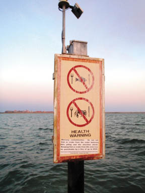
In the late 60's, Alcoa's aluminum manufacturing plant on Lavaca Bay expelled enough mercury-filled waste water into Lavaca Bay to contaminate 64 square miles. Estimations put the figure to be about 67 pounds of mercury per day (permitted by the State at the time), from its location on the northeast side of the bay. In 1970, the practice was discontinued; and in 1988, retaining fish from specific waters ("closed area") was outlawed due to health risks. The meager amount of Lavaca Bay anglers quickly dispersed elsewhere.
Things changed in 1994 when a portion of Lavaca Bay became a Superfund site. Over $110 million in extensive cleanup efforts and restoration put life back into the bay for future anglers. Along with 11 acres of oyster reefs and over 70 acres of marsh furnished, more than 700 acres of prairie became permanently preserved.
 Bill Balboa is no stranger to Lavaca Bay
after being the area's TPWD biologist for more than 11 years. According
to Balboa, the cleanup efforts and renovations were successful. "The
mercury is now contained to a very small area adjacent to Alcoa." In
the small area surrounding Alcoa, the taking of finfish and crabs is still
banned. Health warning signs warn boaters on the perimeter of the contaminated
area.
Bill Balboa is no stranger to Lavaca Bay
after being the area's TPWD biologist for more than 11 years. According
to Balboa, the cleanup efforts and renovations were successful. "The
mercury is now contained to a very small area adjacent to Alcoa." In
the small area surrounding Alcoa, the taking of finfish and crabs is still
banned. Health warning signs warn boaters on the perimeter of the contaminated
area.
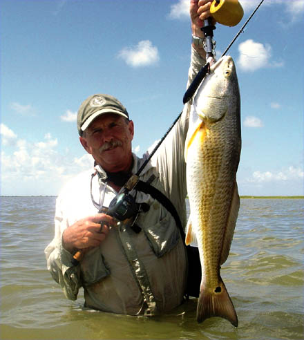
Cox Bay, Keller Bay, and the rest of Lavaca Bay are free of restrictions and open to fishing and the possession of fish. Balboa is confident that Lavaca Bay is healthy and duly supports growing numbers of speckled trout and redfish. "It is doing as well as it ever has. The Lavaca River provides plenty of the essential freshwater that we all know coastal bays need."
When compared to neighboring middle coast bays, Lavaca is a slight oddball. West Matagorda Bay and Port O'Connor supply miles of shoreline fishing and an abundance of sand, grass, guts, and gulf tide. Contrarily, mud and oyster shell reefs compose most of Lavaca Bay. Its thick trees, grassy bluffs, and spoil islands are a drastic change from the salt grass landscape lining the coastal bend. Matagorda and Port O'Connor's easy wades grab a lot of attention from the weekend warrior crowds. Weekend anglers in Lavaca are lucky to hear the whine of another outboard.
"The fishing pressure is wonderful; it just doesn't exist here," says Captain Dwayne Newbern. For the last 11 years, Newbern has fished and guided anglers in Lavaca Bay and surrounding waters. Convenient for Captain Dwayne is his Edna, Texas home. Twenty minutes is all it takes from his back door to the fishing grounds.
Tactically, the biggest factor influencing Newbern's fishing in Lavaca Bay is water clarity. This is typical in a muddy bottomed bay like Lavaca where average water depth is four-feet. Water clarity is considerably affected by high winds. Prolonged calm conditions or cold weather can make Lavaca Bay as clear and emerald green as August surf.
"Most of the fish I catch are between the bridge and the Lavaca River. On windy days, I must adapt to catch fish. This means I'm sometimes limited to the shoreline areas or the Lavaca River."
"When waters calm, I really like fishing along the Highway 35 bridge. There is a lot of rip-rap, logs, and concrete along the bridge that attract a lot of fish." This causeway, connecting Point Comfort and Port Lavaca, is where Newbern and his father experienced one of their most memorable outings together.
"The day's weather was awful. The wind was blowing so hard that the bay looked completely muddy," describes Newbern.
Using a trolling motor along the structure, the duo tied on small D.O.A. Terror Eyez soft plastics. "We allowed them to float with the current and we absolutely slammed fish!" Newbern and his father did not expect such success in the location during high winds, but Newbern is no longer hesitant to try the bridge in less than par conditions.
As Newbern stated, many reefs and underwater structures exist along the bridge - including the remains of the old causeway that was partially destroyed by hurricane Carla and later billed as the "world's longest fishing pier". During seasonal changes, the location serves as a transition zone for fish moving to and from the rivers and creeks on the upper end of the bay. From the end of the Lavaca River to the bridge, bird activity is a dead giveaway of schooling fish year-round.
For locals, Garcitas Creek and the Lavaca River are cold weather hotspots when trout stack in deep water. Newbern focuses nearly all of his winter months activity along edges and drop-offs of the Lavaca River. "I use the trolling motor and cast soft-plastics along the river banks just as I do along the bridge."
Wadefishermen have numerous shoreline and shell reef choices. Newbern swears by one reef in particular - Chicken Foot Reef. It is located on the south side of the west shoreline pier. The big reef hangs just below the water on a normal tide. "It makes for a great wade, but I usually find the fish somewhere between the reef and the bridge's rip-rap using my trolling motor."
Tournament angler and retired biologist, Mike Weixelman has fished Lavaca Bay since the 70's. Weixelman typically wades Lavaca but states that drifting is an ideal way to locate numbers of fish.
"There is a lot of deep shell undiscovered around Gallinipper Reef. With a popping cork and deep rigged Berkley Gulp, you can surely find fish." The nearby spoil islands along the Port Lavaca Ship Channel are very reliable for anglers seeking similar results.
"I can remember surveying a guy from Magnolia, Texas when I worked as a biologist for Lavaca Bay. For months, he arrived at the dock with limits of trout and redfish. I eventually learned that he was wading the spoil islands along the ship channel."
Weixelman deems the west bank along Garcitas Creek as the most underutilized area in the entire bay. On the upper end of the bay, mud and shell structure is prevalent. "No one fishes it and I have caught many redfish on the reefs."
Mike Weixelman can prove that he knows where to find big speckled trout in fall to spring. "Years ago, I helped a friend win a Troutmaster's Tournament in Lavaca Bay. Wade the shoreline from Mud Point to Rhodes Point. It's loaded with 3-5 pound trout."
Lavaca Bay may not possess all of the qualities of a perfect bay system, nevertheless, the bay is sure to offer new water with a fresh challenge and less pressure.
Dwayne Newbern can be reached at (361) 652-7346. Port Lavaca/Calhoun County C of C (361) 552-2959 (800) 556-7678. Fish Finder Map No. 1016 covers Lavaca Bay and Port O'Connor area.
- Capt. Kyle guides from Matagorda (the town) and Port Mansfield
- depending on the season. Give him a call at 979-240-9999 or visit - www.kyletomek.com
for more information.